Seismics
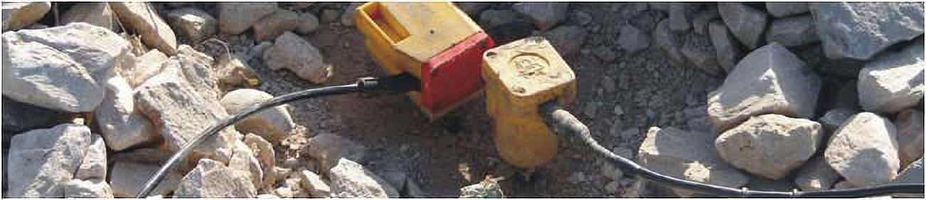
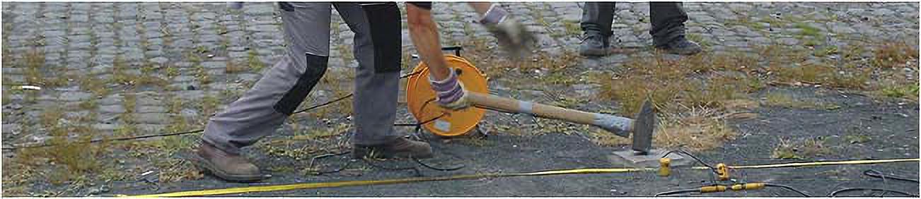
Seismics base on measuring travel times of seismic waves, that propagate through subsurface with material specific velocities. The seismic waves are excited by seismic sources as hammer, accelerated weight drop or explosives.
Investigation depth: 10 meter up to 1000s of meters
Sample applications:
- geological structure (weather layer, aquifers, sediment layers, basis of bedrock)
- parameter of rock and soil (porosity, density, rock classification, characteristic values, earthquake protection)
- fault investigation (gaps, fracture zones)
- detection of caves, banks, objects
Methodically, according to the problem, refraction seismics or reflexion seismics is applied.
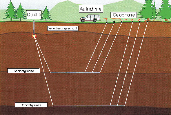
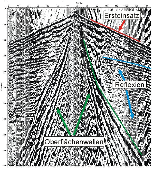
At geological layer bounderies and all other discontinuities in subsurface, where a change of material occurs, the waves are refracted (broken) and reflected. They can be recorded with vibration measurement devices (geophones) spread along a line.
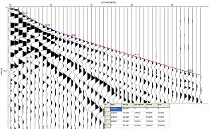
The travel times and amplitudes are displayed in a so called seismogram. After an accurate data processing, a seismic image of the subsoil turns out therefrom. From this, a geological model can be interpreted. For special investigations, horizontal geophones, a 9 component borehole geophone, and the especially developed FAST 24 system are available.
Reflection Seismics
Reflection seismics base on the velocity measurement of elastic waves that are reflected at layer boundaries.
Investigation depth: ca. 10 m bis 1000 m
Sample applications:
- High resolution geophysical surveying near to the surface and of deeper underground (lithological structure, faults, unconformities)
- Detection of lateral facies boudaries
- Reservoir exploration (geothermal energy, natural gas, petroleum, water, …)
Unlike refraction seismics, reflection seismics do not use head waves but reflected waves and their travel times. Seismic reflections raise from layer boundaries (impedance contrast) . The measuring instruments of both methods do not differ, however the measurement configuration can change, depending on the targets of investigation. A distinction is drawn between 2D and 3D reflexion seismics.
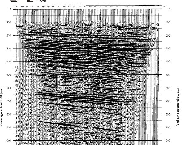
At 2D seismics, source and receivers are usually arranged in a line. The measurement results are processed in an extensive way. The purpose of seismic processing is to reduce unwanted signals like ground roll and to generate a so-called zero offset section (also CMP stack). The CMP stack shows seismic reflexions as a function of time (two-way-traveltime).
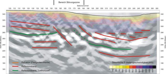
When the CMP stack is done, the reflexions have to be mapped to the right depth position. The depth migration can be done when the seismic velocities are known. The final migrated seismic section can be interpreted to gain geologic information.

Refraction Seismics
Refraction seismics use the refracted energy of artifically excited seismic waves (see also Seismics). For this purpose travel times of head waves, i. e. seismic waves are evaluated that were refracted at layer bounderies in the subsurface.
Investigation depth: up to 50 m (even deeper for research purposes)
Sample applications:
- General geological structures (lithology, fault zones)
- Assignment of rock classes from seismic wave velocities
- Detection of sediment layers and weathering layer thickness
- Detection of bedrock surface
- Investigation of elastic properties and bedding conditions for land development
- Mapping of aquifuges
- Investigation of abandoned waste sitesLandfill investigation
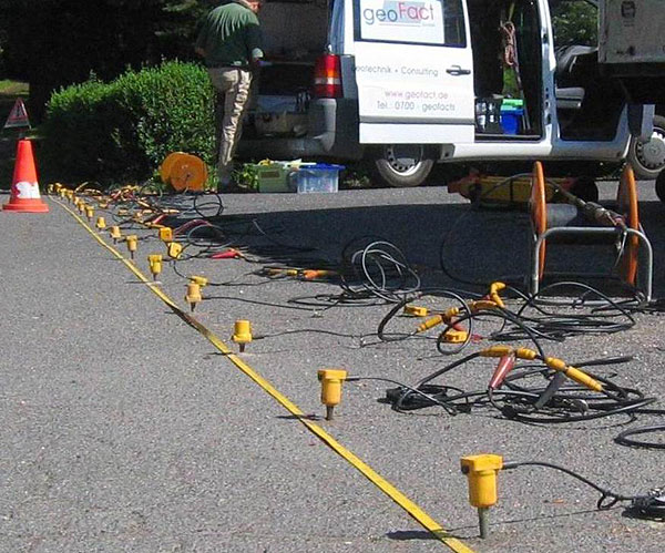
Along lines geophones are put on the ground in regular spacings to measure the ground motion. Afterwards seismic waves are successively excited at different positions (shot points) of the measurement line. Depending on exploration depth geoFact uses a 10 kg sledge hammer (low target depth), an accelerated weight drop or explosives (highest target depth) as seismic source. In water an airgun is used that generates a blast wave by compressed air.
The first step of interpretation is to pick the arrival times (first breaks), that is to determine the time it takes the seismic wave to reach a single geophone. Afterwards inversion technique is applied to this data to generate a model of the subsurface (seismic refraction tomography)